
Assessment of the spatial accessibility to the rabies vaccination campaign in Bogotá, Colombia
Abstract
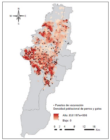
Introduction: The access of Bogota’s population to health services is unknown, and this hinders the planning of health prevention strategies. Objective: To estimate the spatial accessibility to the vaccination sites of the 2011 campaign against rabies in Bogotá, Colombia, and to compare its efficiency with two other spatial coverage methodologies. Materials and methods: Spatial accessibility was determined using the two-step floating catchment area model (2SFCA). We calculated spatial coverage by establishing circular buffer zones using Euclidean distances, and irregular zones around the vaccination sites using Dijkstra’s algorithm on the city’s street network. Results: The spatial coverage of the program was 78.4% using the circular buffer zones, and 60.2% using Dijsktra’s algorithm. The spatial accessibility analysis revealed that the periphery of the city had the lowest accessibility to the program. This peripheral area is a very critical zone because it is an urban-rural interface, which represents a risk for the re-introduction of rabies in the city. Conclusions: The 2SFCA spatial accessibility model is an effective tool to identify isolated areas, evaluate health services use more precisely, and provide basis for their strategic location. We concluded that this approach had the potential to improve resource efficiency when planning rabies control programs in urban environments such as Bogotá. The findings emphasize the need for surveillance and intervention in isolated areas with low access to services.
Downloads
References
Cediel-Becerra NM. Asociación entre la epidemiología de la rabia canina, la organización del programa de rabia y las condiciones socio-económicas en Colombia. Estudio ecológico (tesis). Bogotá: Universidad Nacional de Colombia; 2009.
Páez A, Rey G, Agudelo C, Dulce A, Parra E, Díaz-Granados H, et al. Brote de rabia urbana transmitida por perros en el distrito de Santa Marta, Colombia, 2006-2008. Biomédica. 2009;29:424-36. http://dx.doi.org/10.7705/biomedica.v29i3.14
Cediel N, de la Hoz F, Villamil LC, Romero J, Díaz A. Epidemiología de la rabia canina en Colombia. Rev Salud Pública. 2010;12:368-79. http://dx.doi.org/10.1590/S0124-00642010000300003
Páez A, Meza J, Calvo P, Garzón P. Niveles de inmunidad humoral conferidos con la primera dosis de la vacuna antirrábica en caninos con dueño de la ciudad de Bogotá, Colombia. Revista de Investigación. 2007;7:191-7.
Secretaría Distrital de Salud. Jornada de vacunación canina en Bogotá. 2008. Fecha de consulta: 8 de enero de 2013. Disponible en: http://www.saludcapital.gov.co/Lists/Anuncionprincipales/DispForm.aspx?ID=65
Walteros DM, Castro Á. Rabia humana y rabia animal, situación actual en Colombia hasta el periodo epidemiológico décimo de 2012. Informe de evento. Bogotá: Instituto Nacional de Salud; 2012. p. 1-29. Fecha de consulta: 8 de enero de 2013. Disponible en: http://www.ins.gov.co/lineas-de-accion/Subdireccion-Vigilancia/Informe de Evento Epidemiolgico/RABIA 2012.pdf
Wan N, Zou B, Sternberg T. A three-step floating catchment area method for analyzing spatial access to health services. Int J Geogr Inf Sci. 2012;26:1073-89. http://dx.doi.org/10.1080/13658816.2011.624987
Polo G, Acosta CM, Dias RA. Spatial accessibility to vaccination sites in a campaign against rabies in São Paulo city, Brazil. Prev Vet Med. 2013;111:10-6. http://dx.doi.org/10.1016/j.prevetmed.2013.03.010
Dai D. Racial/ethnic and socioeconomic disparities in urban green space accessibility: Where to intervene? Landsc Urban Plan. 2011;102:234-44. http://dx.doi.org/10.1016/j.landurbplan.2011.05.002
Luo W, Wang F. Measures of spatial accessibility to health care in a GIS environment: Synthesis and a case study in the Chicago region. Environ Plann B Plann Des. 2003;30:865-84. http://dx.doi.org/10.1068/b29120
Khan A. An integrated approach to measuring potential spatial access to health care services. Socioecon Plann Sci. 1992;26:275-87. http://dx.doi.org/10.1016/0038-0121 (92)90004-O
Guagliardo MF. Spatial accessibility of primary care: Concepts, methods and challenges. Int J Health Geogr. 2004;3:1-13. http://dx.doi.org/10.1186/1476-072X-3-3
Joseph A, Bantock P. Measuring potential physical acces-sibility to general practitioners in rural areas: A method and case study. Soc Sci Med. 1982;16:85-90. http://dx.doi.org/10.1016/0277-9536(82)90428-2
Langford M, Higgs G. Measuring potential access to primary healthcare services: The influence of alternative spatial representations of population. Prof Geogr. 2006;58:294-306. http://dx.doi.org/10.1111/j.1467-9272.2006.00569.x
Wang L. Immigration, ethnicity, and accessibility to culturally diverse family physicians. Health Place. 2007;13:656-71. http://dx.doi.org/10.1016/j.healthplace.2006.10.001
Wang F, McLafferty S, Escamilla V, Luo L. Late-stage breast cancer diagnosis and health care access in Illinois. Prof Geogr. 2008;60:54-69. http://dx.doi.org/10. 1080/00330120701724087
Yang D-H, Goerge R, Mullner R. Comparing GIS-based methods of measuring spatial accessibility to health services. J Med Sys. 2006;30:23-32. http://dx.doi.org/10. 1007/s10916-006-7400-5
Polo G, Mera-Acosta C, Ferreira F, Dias RA. Location-allocation and accessibility models for improving the spatial planning of public health services. PLoS One. 2015;16:1-14. http://dx.doi.org/10.1371/journal.pone.0119190
Departamento Administrativo Nacional de Estadística. Boletín Censo General 2005. Perfil Bogotá. Bogotá: DANE; 2010. Fecha de consulta: 19 de enero de 2013. Disponible en: http://www.dane.gov.co/files/censo2005/PERFIL_PDF_CG2005/11001T7T000.PDF
Infraestructura de Datos Espaciales para el Distrito Capital (IDECA). Catálogo de Datos Geográficos, Nomen-clatura Domiciliaria. Bogotá: IDECA; 2012.
Vega-Aragón RL, Espinosa-Garzón GH, Castillo-Bejarano L. Análisis de la población canina en el distrito capital, 2005. Investig Segur Soc Salud. 2007;9:205-27.
Secretaría Distrital de Salud. Gran jornada de vacunación y adopción de perros y gatos. 2011. Fecha de consulta: 10 de enero de 2013. Disponible en: http://www.saludcapital.gov.co/Lists/Anuncionprincipales/DispForm.aspx?ID=533
Bell S, Wilson K, Shah TI, Gersher S, Elliott T. Investigating impacts of positional error on potential health care acces-sibility. Spat Spatiotemporal Epidemiol. 2012;3:17-29. http://dx.doi.org/ 10.1016/j.sste.2012.02.003
Zwiefelhofer D. Batch Geocoding. 2012. Fecha de consulta: 2 de diciembre de 2012. Disponible en: http://www.findlatitudeandlongitude.com/batch-geocode/#.Vw6k_PnhDIU.
Dai D. Black residential segregation, disparities in spatial access to health care facilities, and late-stage breast cancer diagnosis in metropolitan Detroit. Health Place. 2010;16:1038-52. http://dx.doi.org/10.1016/j.healthplace. 2010.06.012
Marpet ML. On threshold values that separate pedestrian walkways that are slip resistant from those that are not. J Forensic Sci. 1996;41:747-55. http://dx.doi.org/10.1520/JFS13992J
Secretaría Distrital de Ambiente. Plan Institucional de Gestión Ambiental – PIGA. Consulta de indicadores ambientales - 2012. Fecha de consulta: 10 de enero de 2013. Disponible en: http://ambientebogota.gov.co/ko/plan-institucional-de-gestion-ambiental-piga1
Gutiérrez J, García-Palomares JC. Distance-measure impacts on the calculation of transport service areas using GIS. Environ Plann B. 2008;35:480-503. http://dx.doi.org/10. 1068/b33043
Some similar items:
- Jorge Sánchez, Ruth Ramírez, Ricardo Cardona, The frequency of allergic reactions to the triple viral vaccine in 94 patients with egg allergy , Biomedica: Vol. 38 No. 4 (2018)
| Article metrics | |
|---|---|
| Abstract views | |
| Galley vies | |
| PDF Views | |
| HTML views | |
| Other views | |